Collaborative landscape planning is possible in Cambodia’s Prek Thnot Watershed
By Sokh Heng, So Thea and Edward V. Maningo. October 2018.
Land-use conflicts and problems in Cambodia’s Prek Thnot Watershed have intensified with population growth. Land scarcity has led to escalation of resource conflicts and increased human encroachment on previously uninhabited lands that were once critical wildlife habitats. These ecosystems are fragile and sensitive to disturbances. Landscape approaches to planning have become popular among resource managers as an effective means for addressing natural resource degradation and enhancing ecosystem services and biodiversity benefits. There are many different types and definitions of landscape, depending on users’ objectives or interests. From a management perspective, it is useful to consider landscapes as consisting of interacting ecosystems within an area, across which humans interact with their immediate environment. In a watershed landscape, interactions between different land uses can easily be identified (e.g. erosion and hydrological functions as a land health indicator in the uplands).
The landscape of Prek Thnot Watershed is a mosaic of various ecosystems and pockets of forest that have mostly become geographically isolated, with sporadically distributed agricultural developments. Over time, farming has encroached on the once verdant forests and laid bare vast areas of this watershed. The rapid depletion of forest cover has been attributed to poor planning as the various requisites and locations of different land uses in the watershed were not properly identified.
Landscape-level planning has gained more attention as knowledge and understanding about interactions between ecosystems at the landscape scale have deepened. The outcomes of any stakeholders’ actions will affect other landscape units: Farmland expansion affects riparian areas, wildlife and fish habitats; timber harvesting accelerates soil erosion and intensifies sedimentation; forest management must consider local people who depend on forests for their livelihoods; increasing upland crop production through the use of fertilizers, pesticides or forest clearing must consider fishing communities and downstream communities that might be affected by sedimentation and surface runoff.
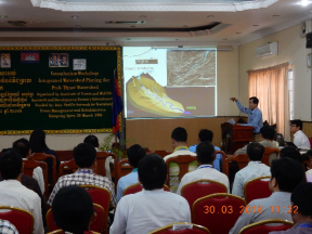
Presentation of the watershed concept with stakeholdersduring a consultative workshop in Kampong Speu Province.
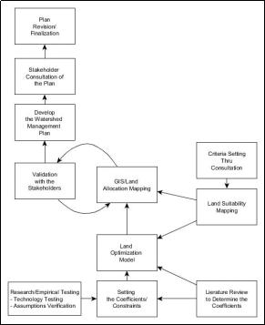
Steps involved in developing the IWMP for Prek Thnot Watershed

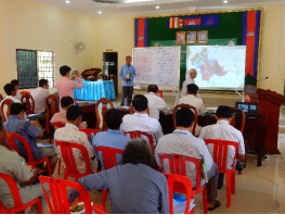
A consultation workshop for stakeholders attended by government officials.
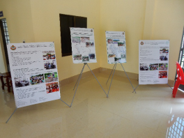
Information display at a consultation workshop.
Explaining the land allocation outcomes tostakeholders during the workshop in Kampong Speu.

Local community members providing inputs during the land-use planning exercises.
Land-use conflicts and problems in Cambodia’s Prek Thnot Watershed have intensified with population growth. Land scarcity has led to escalation of resource conflicts and increased human encroachment on previously uninhabited lands that were once critical wildlife habitats. These ecosystems are fragile and sensitive to disturbances. Landscape approaches to planning have become popular among resource managers as an effective means for addressing natural resource degradation and enhancing ecosystem services and biodiversity benefits. There are many different types and definitions of landscape, depending on users’ objectives or interests. From a management perspective, it is useful to consider landscapes as consisting of interacting ecosystems within an area, across which humans interact with their immediate environment. In a watershed landscape, interactions between different land uses can easily be identified (e.g. erosion and hydrological functions as a land health indicator in the uplands).
The landscape of Prek Thnot Watershed is a mosaic of various ecosystems and pockets of forest that have mostly become geographically isolated, with sporadically distributed agricultural developments. Over time, farming has encroached on the once verdant forests and laid bare vast areas of this watershed. The rapid depletion of forest cover has been attributed to poor planning as the various requisites and locations of different land uses in the watershed were not properly identified.
Landscape-level planning has gained more attention as knowledge and understanding about interactions between ecosystems at the landscape scale have deepened. The outcomes of any stakeholders’ actions will affect other landscape units: Farmland expansion affects riparian areas, wildlife and fish habitats; timber harvesting accelerates soil erosion and intensifies sedimentation; forest management must consider local people who depend on forests for their livelihoods; increasing upland crop production through the use of fertilizers, pesticides or forest clearing must consider fishing communities and downstream communities that might be affected by sedimentation and surface runoff.
Presentation of the watershed concept with stakeholdersduring a consultative workshop in Kampong Speu Province.
Landscape planning must meet the basic requirements of being technically, socially and political acceptable. With the advent of cutting-edge mapping technology, technical acceptability, which includes satisfying carrying capacity, economic viability and land suitability criteria, is perhaps the easiest requirement to comply with. Social and political criteria are considered the most challenging issues. Achieving the desired outcomes requires support from individuals by engaging stakeholders in all phases of watershed management planning. However, collaborative landscape planning and management can be challenging. This is mainly because of the difficulty involved in bringing together all actors who may be affected by the plan. Without an appropriate approach, disputes may arise between certain stakeholders, making consensus practically impossible.
The APFNet-funded project has supported the implementation of an integrated watershed management plan (IWMP) through local consultations. The Prek Thnot Watershed showcased a participatory process of bringing together different stakeholders to develop a common vision despite conflicting interests. The planning phase for an IWMP is divided into three stages: Designing an optimal land allocation model; drawing up the land allocation map; and developing the watershed management plan based on land allocations. Multi-stakeholder consultation is considered the cornerstone of collaborative management in the development and legitimization of the IWMP.
The APFNet-funded project has supported the implementation of an integrated watershed management plan (IWMP) through local consultations. The Prek Thnot Watershed showcased a participatory process of bringing together different stakeholders to develop a common vision despite conflicting interests. The planning phase for an IWMP is divided into three stages: Designing an optimal land allocation model; drawing up the land allocation map; and developing the watershed management plan based on land allocations. Multi-stakeholder consultation is considered the cornerstone of collaborative management in the development and legitimization of the IWMP.
Steps involved in developing the IWMP for Prek Thnot Watershed
The consultative planning process. The Prek Thnot Watershed project took a phased approach to develop a land allocation map and IWMP. The project initially conducted a series of information dissemination workshops with different stakeholders to explain landscape planning concepts and land-use siting criteria. These consultations ensured that the criteria for screening land uses came from local stakeholders as part of the legitimization process. The consultations also set the watershed vision and expected watershed services, which are key elements in shaping the watershed management plan and the proposed measures to mitigate incompatible land uses. The consultation workshops demonstrated that consensus on the criteria to be considered in land-use planning and land-use allocations can be readily attained through multi-stakeholder engagement.
A consultation workshop for stakeholders attended by government officials.
Mr Tep Nem is the Chief of Trapaing Chor commune, Aoral district. In his opinion, “In our commune, we used to attend seminars on watershed management planning. We developed plans to manage sloping areas. In Trapaing Chor commune, there are several agriculture developers such as economic land concession companies and plantations owned by the famers. Their activities have caused the loss of our forest. The clear-cutting of trees has generated erosion of topsoil especially in the rainy season, siltation and shallowing of streams, rivers and lakes. The land-use plan that will promote the efficient management of Prek Thnot Watershed will benefit Trapaing Chor commune. We anticipate that the plan will help to increase forest cover and fruit tree growth and prevent soil erosion. The plan will control cultivation, whether by firms or families, on sloping areas, minimize the use of fertilizers and increase family income. Our commune will be more than happy to cooperate and support this plan.”
Information display at a consultation workshop.
Mapping and drafting of the initial IWMP. Spatial mapping proceeded after agreement was reached on the location and site selection criteria for different land uses. GIS was used to map suitable areas using the criteria provided by workshop participants. This land allocation map was integrated into the IWMP.
Validation. Two district validation workshops (in Aoral and Phnum Sruoch) were organized to obtain stakeholders’ feedback on the IWMP. The validation of the IWMP with the community is an important component of the planning process. The aim was to confirm whether the design of the plan had captured the aspirations and the land suitability set by the stakeholders. Most of the participants consented to the land allocations, although one slight amendment was made – they wanted to allocate an area for ecotourism. Some parts of the watershed were therefore reallocated to conservation for compatibility with the proposed ecotourism project. The cultivated areas of the zone identified for ecotourism have been earmarked for the promotion of sustainable land-use management (e.g. conservation agriculture or agroforestry) or agritourism.
Again, the project demonstrated that reaching prior agreement on land suitability criteria through stakeholder engagement at the validation workshop resulted in very few objections when the results of the land allocations were announced.
Explaining the land allocation outcomes tostakeholders during the workshop in Kampong Speu.
hallenges encountered. The process has shown the effectiveness of the approach in devising land allocations that are acceptable to stakeholders. Some issues that had been resolved in previous workshops were raised again in the validation session. It was learned that some of the participants did not attend the consultation workshop. Instead of sending the representative who attended the first workshop, some organizations and line agencies sent different representatives who were new to the concept and process of landscape planning. This is a common occurrence when conducting a series of stakeholder consultations. Any queries or objections were addressed by explaining what had transpired at the previous workshops.
Local community members providing inputs during the land-use planning exercises.
This project showed that multi-stakeholder consultation and engagement is an important component of a socially and politically acceptable plan. Collaborative landscape planning by bringing together different stakeholders to secure a shared vision for a sustainable future despite possible conflicts of objectives or interests is possible. The experience also demonstrated that consultative planning should not be propositioned as a “one-shot deal”. Legitimizing the perspectives of different stakeholders is a long and systematic process.